

***WINTER STORM WATCH FOR ALL OF EASTERN OKLAHOMA NOON FRIDAY UNTIL 6 AM SUNDAY FOR ACCUMULATING SNOW AND VERY LOW WIND CHILLS***
A few light to moderate rain showers could fall early Wednesday morning in far southeast Oklahoma. Otherwise, lots of sunshine again on your Wednesday. Lows near 30° with highs in the low 50s.
Mid 20s to start Thursday and then upper 40s to around 50°. Partly cloudy skies. Take advantage of the next couple of days to run any errands and do preps before the cold and snow move in.
A strong Arctic front will move through Green Country Friday morning. Look for dropping temperatures through the day. Starting around 30° or so and diving into the 20s with much lower wind chills. We'll have wind chills below 0° by Friday night.
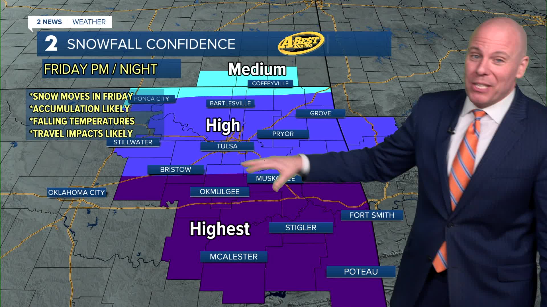
In terms of precipitation, there could be a brief wintry mix south of Tulsa, but we expect for this to mostly be a snow event here in Green Country. Timing of when it starts is still uncertain Friday as the falling snow will have to overcome a lot of dry air. Earliest start would be mid-morning to midday, but some data holds off the snow until afternoon and evening. We'll be adjusting this as confidence increases.
The snow could become moderate in spots Friday night into Saturday with travel impacts likely in areas due to accumulating snow. Several inches of snow look likely with the heaviest snow falling across the south half of our forecast region, especially I-40 and south. We'll be watching dry air filtering into the system from the north that could limit amounts closer to the OK/KS line. Lows Saturday just below 10° with highs in the teens. Below 0° wind chills.
Snow looks to continue Saturday night and maybe linger in spots early Sunday morning. Lows Sunday in the single digits with wind chills near 0° and below. Afternoon highs near 20°. Snowfall amounts may range from 2" to 4" near the Oklahoma and Kansas line, to 3" to 7" along HWY 412, including Tulsa, to 6" to 10"+ near and south of I-40.
Mostly sunny on Monday with lows just above 0°, but wind chills below 0° with highs in the 20s.
Stay tuned to our forecasts as we'll continue to adjust things in the coming days as we get better data.
Stay in touch with us anytime, anywhere --
- Download our free app for Apple, Android and Kindle devices.
- Sign up for daily newsletters emailed to you
- Like us on Facebook
- Follow us on Instagram
- Watch LIVE 24/7 on YouTube
